CruiseMapper provides cruise ship schedules (itinerary timetables, sailing calendars, departure dates, prices), as well as cruise port schedules (ship departures and arrivals by port). These are short links jumping down directly to the topics of cruise tracker (real-time AIS ship location tracking), cruise itinerary information, tendered ports.
"Cruise Schedule" is synonymous to "Cruise Calendars" and "Cruise Timetables". It signifies a list of all officially announced sailing dates on which a particular passenger ship will be cruising. As details, cruise itinerary schedules show all departures (home-ports embarkation dates and times), all ports of call dates and times (where and when the vessel will be along its itinerary route) and disembarkation dates and times (of arrival in the last port on the route).
Cruise SHIP Schedule
Most ships dock and stay in one port for 1 or 2 days (rarely 3, the majority are 1-day port stays). Depending on destination/region, company and itinerary - ships visit (call on) 1 to 3-4 different ports, simply because visiting many ports means more port charges and Gov fees, and longer itineraries. This also means not cheap cruises and fewer passengers. Not so many travelers are fortunate to have the time and money to do longer voyages. However, on longer cruises, the total number of ports of call may sour up to 40, and even more (on Around The World tours).
"Longer than usual" itineraries are also most relocation cruises (RepositionCruises.com), which are always one-ways, also roundtrip Transatlantic cruises (ocean crossings between Europe and USA-Caribbean or South America), all Panama Canal transits, World Cruises (segments), also the optional "B2Bs/Back-To-Backs" (consecutive voyages combining 2 itineraries on the same or different boats).

At CruiseMapper, you will have access to segmented information from a regularly updated database with departure dates, itineraries and prices (fares) to compare on sea / ocean-going passenger ships, as well as on riverboats in Europe, USA, and Asia (Russia, India, China, Mekong).
Our cruise ship prices are the lowest rates (cruise fares) for ship's lowest category cabins (basic types). These main stateroom types are Inside, Outside/OceanVew, Balcony (with step-out balconies) and Suites. For example, river cruise boats do not have Inside rooms, some vessels don't have cabins with balconies, most top luxury cruise ships (with all-inclusive deals) have only Suites (all-suite ships). Keep in mind, that the prices shown may be subject to fluctuations - they could be different at the time of booking influenced by factors, such as different travel agency rates, group booking rates, various types of discounts (resident, military, loyalty program, member discounts, etc).
In each CruiseMapper ship schedule, along with all cruise dates and prices you'll find also the vessel's basic statistics - former names (if any), sister ships, weight, length and width, capacity, class, number of cabins, max capacity, info on feature onboard amenities, facilities and services, link to the ship's current location (AIS position on a digital map), link to its staterooms and deck plan pages for detailed information on cabins and current cruise deck plans.
Cruise Itinerary
"Cruise itinerary" provides information where is your ship going (destination and ports of call) and when (sailing schedule). Cruise itineraries are often called "cruise routes" or the general "cruise destinations". These are the sailing regions operated by passenger shipping lines (including ferry lines/operators), cruise companies or chartered vessels (ship/riverboat) operators.
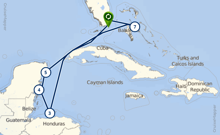
A typical cruise itinerary example is the route of the world's biggest passenger ship - Symphony Of The Seas (schedule 2019). This vessel is operated by RCI (Royal Caribbean International) - world's second-largest passenger shipping operator (after Carnival Corporation). This 7-day cruise itinerary sample is a roundtrip to Western Caribbean (destination) from Miami Florida (departure port/homeport) visiting ports of call/call ports in Honduras (Roatan Island), Mexico (Costa Maya, and Cozumel) and Bahamas (Nassau).
The following CruiseMapper-generated itinerary map shows the interlinked ports (homeport in green, call ports in white) and the day in which the liner visits each port.
By annual passenger traffic (statistical data 2019), the Caribbean's top-10 largest airports are:
- Luis Munoz Marin Airport/aka Isla Verde (San Juan Puerto Rico) with ~9,5 million pax
- Punta Cana Airport (Punta Cana Dominican Republic/La Romana) with ~7,2 million pax
- Jose Marti Airport (Havana Cuba) with 5,7+ million pax
- Sangster Airport (Montego Bay Jamaica) with ~4,8 million pax
- Lynden Pindling Airport (Nassau Bahamas) with ~4,1 million pax
- Las Americas Airport (Santo Domingo Dominicana) with ~4 million pax
- Piarco Airport (Port-of-Spain Trinidad) with 2,8+ million pax
- Queen Beatrix Airport (Oranjestad Aruba) with 2,5+ million pax
- Pointe-a-Pitre Airport (Pointe-a-Pitre Guadeloupe) with ~2,5 million pax
- Grantley Adams Airport (Bridgetown Barbados) with ~2,3 million pax
This explains why these port cities are used as seasonal turnaround ports for homeporting (roundtrip itineraries) by many major cruise companies with ship deployments in the Caribbean.
Itinerary changes
Factors and circumstances that can lead to a change of cruise schedule (and often of the itinerary):
- departure/arrival times can be affected by weather
- in some ports, cruise times can be changed due to air pressure or tidal times
- cruise schedule changes due to mechanical problems or an incident/accident
- itinerary change by the line/operator, based on safety or security reasons, strikes or civil unrest, port closings, local Government agencies' travel warnings or advisories, or for any other reason whatsoever. It's part of the line's policy about changing port calls, arrival/departure times, etc. Generally, If a call port is skipped from your scheduled itinerary, all Government fees and port taxes for that port will be refunded to the passengers' shipboard credit accounts.
For detailed news reports on major cruise line incidents and ship accidents, you can visit our CruiseMinus (accidents and incidents) section. Know, that weather-related itinerary changes are not reported at Cruise Minus.
Cruise Itinerary Data - Template Details
For any cruise itinerary, there are 6 main elements determining the whole data (listed high to low priority):
- Name of the ship and the company/operator line.
- Destination - which one of world's cruise regions your ship will be visiting in a specific time of the year.
- Embarkation port (port of departure/homeport, getting on the ship) and the country from which it leaves. Note: your place of residence defines lots of variables determining the total cost of your cruise vacation as prices per person. Some of these are flight tickets and transfers, all kinds of transportation, parking, hotel stay, etc.
- Disembarkation port (the last port of arrival, getting off the boat). Most ship cruises are operated with roundtrip itineraries, meaning you will embark and disembark in the same port. However, many sea ships and riverboats also offer one-way cruise tour itineraries (different embarkation/disembarkation ports). With one-way deals are also all transition cruises (ship relocation), World Cruise segments (full "Round The World" itinerary is usually roundtrip), most Panama Canal and Transatlantic ship crossings.
- Voyage length and number of call ports - these are all ports your itinerary includes - another major price-determining variable. Shortest trips (on large liners) are 2-days in length (Cruises to Nowhere, without any call ports). Longest voyages may offer up to 170+ days (Around The World voyages). World cruise deals offer numerous call port visits in various countries and several destinations (sometimes on all continents), plus great ticket prices as rates per person per day. On ship relocation cruises you'll visit a very small number of seaports (none on some Transatlantic crossings).
- And finally - fly- or no-fly cruises. Generally, with flight-and-cruise deals, you buy travel package consisting of cruise ship tickets and one-way (or roundtrip) airfare/flight tickets.
- Always optional choices (at extra cost) are land tours/shore excursions, hotel packages, spa and drink packages, and other extras in the "big splurge" category.
Types of Cruise Itineraries
- "sea intensive" - offer less or none ports of call, no shore excursions and city tours, less money-spending ashore and much more on-board splurging.
- "port-intensive" - offer lesser number of days at sea (but at least one) and many call ports (almost a new one each day of your voyage), meaning you sail at night, visit ports in early morning, stay in ports until early evening (or late into the night, depending on destination and ship/boat).
- "balanced" - offer more time between ports, usually one or two days at sea, followed by one port-day, and so on.
- "Cruise To Nowhere" is a round-trip itinerary with only one port and duration of 1 or 2 nights. Generally, this type of voyages is rare. They are usually offered by some of the largest passenger ships, with departures from some of the world's biggest cruise ports - like New York City (USA), Southampton (UK), Sydney (Australia). On small ships and pleasure crafts, such deals could be offered regularly, but more like "sleeping over" harbor cruises or party cruises - with an overnight stay onboard and a scheduled entertainment program for the evening.
- "Back To Back Cruises" are 2 or 3 voyages on the same ship combined/interlinked - following one after another. In rare cases, the ships may be different, but always from the fleet of the same cruise line. Such itineraries usually combine sailings to different destinations or in different regions. Some of the examples for B2B cruises are the combinations: Caribbean with Panama Canal transition (on relocation to Alaska), 7-day roundtrip from Vancouver with a short oneway to port in California (on relocation from Alaska), roundtrip from Sydney with oneway to Singapore (on relocation from Australia to Asia), roundtrip Mediterranean or Caribbean with a repositioning Transatlantic crossing, 2 combined roundtrips from port in Florida to Caribbean (Southern plus Eastern, Western plus Eastern), etc.
- Repositioning voyages are always with oneway itineraries and longer than usual. Ship relocation voyages are usually offered in Spring and Fall when cruise ships reposition between two different operational regions. In this category fall most of the Panama Canal and Transatlantic cruises and all Suez Canal transits. Other examples for ship relocation itineraries are: between Alaska and Australia, between Australia and Asia, between South Africa and Europe or Asia.
- "one-way" and "roundtrip" - with different/same embarkation and disembarkation ports.
And our very last "categorization approach" - cruise itinerary types according to the passenger shipping vessels. All passenger marine vessels can operate on both one-ways and round-trips but differ greatly as to operational destinations, cabin sizes and rates, amenities and activities on board, fellow passengers, trip duration, etc. These main itinerary types are:
- (oceanic) sea ship cruises
- river ship (riverboat) cruises
- ferry cruises
- (freighter) cargo ship cruises.
Cruise Tracker
At our cruise tracker (website's front page) you'll find a search box to type and select from a huge list of all cruise vessels available for tracking at CruiseMapper. This is our convenient cruise ship tracker showing current positions and also allowing further to compare itineraries, departure dates, and fares by vessel. Our tracker shows real-time vessel locations based on AIS data transmitted to VesselFinder. This feature is integrated into each ship page. Ship tracking allows you to see vessel's current itinerary route on a digital map, with information on its speed, previous and next call port, estimated port arrival time.
CruiseMapper also tracks riverboats (mainly in Europe and the USA), hotel barges, cruise ferries and also Russian river ships (world's largest ever made) and icebreakers. You can also track all major river cruise lines ships as itineraries and current positions. World's best riverboats are from the fleets of leading companies like Viking, AMAwaterways, Avalon Waterways, Uniworld, American Cruise Lines, CroisiEurope, Scenic Cruises, Arosa.
We also have a huge fleet of chartered riverboats operating in Asia (Yangtze, Irrawaddy, Mekong), Africa (Nile River, Lake Nasser, Chobe River / Botswana), USA (Mississippi, Ohio, Snake, Columbia) and Ukraine-Russia (Volga, Dnieper, Lena, Black Sea).
AIS tracking of cruise ships positions
Tracking cruise ships' current positions (location at sea or in port now) has never been that easy thanks to the AIS technology (abbrev from "Automatic Identification System"). This is an automatic system used for tracking cruise ship positions and by vessel tracking services (VTS), locating and identifying cruise ships by AIS data exchange between nearby cruise ships and AIS receiving stations.
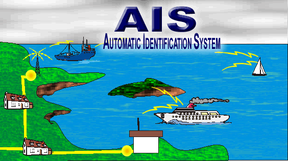
Real-time AIS tracking of cruise ships starts in 2002 when all passenger ships and merchant vessels that are more than 300 gross tons were obliged to install AIS transponders aboard. The new regulation for mounting AIS on all existing cruise ships has been implemented bit by bit.
Technically, the AIS tracking of cruise ship position's system uses very high frequency (FHV) radio channels to transmit encoded information and localize the current position of cruise ships at sea. The typical range of AIS receiving stations is around 30-50 nautical miles depending on the weather condition.
AIS transponder of each cruise ship transmits AIS messages that are being received by AIS receiving stations located ashore. Transmitted AIS information reports the current cruise ship position, its speed, and course over ground. Generally, the cruise ship officer is accountable for setting the cruise ship's AIS transponder to transmit information like cruise ship name, its dimensions, the type of the cruise ship and the estimated time of arrival. However, this kind of AIS information isn't always correctly entered and it might be outdated.
According to International Maritime Law, it is mandatory for all anchored or moored cruise vessels to transmit their current position at least every three minutes. Cruise ships sailing with speed up to 14 knots are required to transmit their current location every 10 seconds; at up to 23 knots speed, every 6 seconds; and those sailing with speed over 23 knots need to transmit their current position every 2 seconds. Additionally, the static AIS information, like vessel name, its destination, and ETA, is being transmitted in separate AIS messages every 6 minutes. This information is used for vessel tracking purposes.
The basic utility of using AIS technology is facilitating communication between cruise ships, passenger ships, and commercial vessels. The World Atlantic Rally for Cruisers (ARC) reported a greater number of ship response after calling a vessel by its name, rarely providing an alteration of the passenger ship course by the give-way ship. Here are some comments regarding the AIS system of the ARC's participants.
- "AIS tracking of cruise ships has never been that sophisticated. There is also no effective system than the AIS when it comes to maritime safety." - John Sandors, Branec IX
- "AIS system is of great importance; despite high cost for transmitting units and the high power consumption for private yachts, it must be mandatory for all ships, not only passenger vessels and those over 300 tons." - Antony Langevin, Into the Deep
- "I would never leave the port without having AIS-installed onboard my ship. It's a great system, which enables any cruise ship to be called by its name." - Megan Rathford, Malmaani.
Next photo shows China's Yuanwang-class satellite tracking ship.
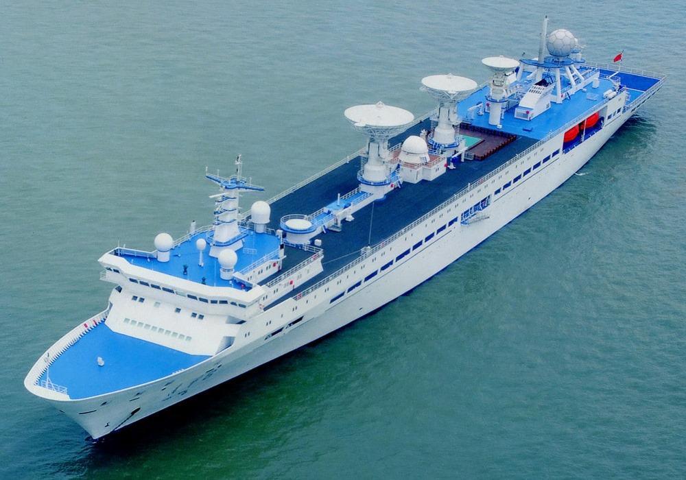
This class (translated "Long View") ships are used for tracking of satellites and intercontinental ballistic missiles. From what is known about the vessel's details, it has displacement tonnage 21,000 tons (fully loaded), crew capacity 470, LOA length 190 m (620 ft). The ship's propulsion is Sulzer, allowing top speed 20 Kn (23 mph / 37 kph). This ship gave China (for the first time ever) the ability to track foreign satellites, as well as satellite and missile launches. The last 2 vessels of this series were constructed in 2007.
Cruise PORT Schedules
In our cruise port schedule section, you will find a search box from which can search in a huge list of thousands of cruise ship ports. You just gave to type the name of the port you're looking for and select it. Depending on itinerary/destination, in cruise ports of call ships dock (or anchor) for a short period of time - from several hours up to 2 overnights (like in King's Wharf, Bermuda). At each cruise port schedule you will find port and cruise terminals information, photos, digital map (port's location) and schedule timetables (all departure dates and ships in port by date.
CruiseMapper's port and cruise ship schedule data will help you in planning better your always excitingly-new ship travel vacations. By using our detailed and regularly updated cruise timetables, you will know all sailing dates and the port times, which information is needed for booking shore excursions, city tours and other activities in ports of call.
Tendered cruise ports
Next, are listed all large seaports at which cruise ships tender their passengers ashore. Currently, these ports don't have the needed infrastructure (quay, pier, wharf) with the capacity to berth large cruise vessels. Passengers have ferried ashore (and back to the liner) via the ship's own tender boats or locally-provided tenders (tour boats).
- Akaroa, New Zealand
- Russel, Bay of Islands, New Zealand
- Belize City, Belize
- Cabo San Lucas, Mexico
- Ixtapa-Zihuatanejo, Mexico
- Cannes, France
- Bar Harbor (Maine, USA)
- Catalina Island (California, USA)
- Kona (Hawaii, USA)
- Lahaina (Hawaii, USA)
- Sitka (Alaska, USA)
- Newport (Rhode Island, USA)
- Catalina Island, Dominica
- Leith-Edinburgh (Scotland, UK)
- Grand Cayman (UK, Caribbean)
- Greek Islands (Eastern Mediterranean)
- Half Moon Cay (private Island, Bahamas)
- Little Stirrup Cay (private island, Bahamas)
- Isle of Pines, New Caledonia
- Lifou, New Caledonia
- Mare, New Caledonia
- Mystery Island, Vanuatu
- Wala, Vanuatu
- Suva, Fiji
- Moorea, French Polynesia
- Bora Bora, French Polynesia
- Puerto Montt, Chile
- Punta Arenas, Chile
- Gustavia (St Barthelemy, France, Caribbean)
- Virgin Gorda BVI